You are viewing the Initial Version, the most recent version of this dataset.
1 version(s) available
Date of publication: June 20, 2025
Version 1
Date of publication: June 20, 2025
Type of change:
Description:
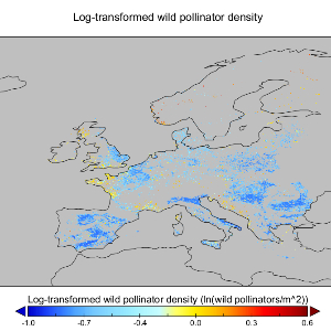
Wild pollinator densities in European agricultural landscapes (NaturaConnect)
by Liam VezzaniWe estimated wild pollinator density (expressed as the natural logarithm of abundance per m²) in cropland cells across Europe for the current state and three future scenarios. The dataset encompasses two temporal references: one for 2020 and three future scenarios for 2050. All four maps were produced by independently applying the same statistical model to land system maps for each year. Results from 2020 are included in each future scenario for ...(continue reading)
DOI 10.25829/ka4q38Citation
Vezzani, L. (2025). Wild pollinator densities in European agricultural landscapes (NaturaConnect) (Version 1) [Dataset]. German Centre for Integrative Biodiversity Research. https://doi.org/10.25829/ka4q38modelEuropecroplandRCP scenariospollinators
| Entities |
|---|
| Pollinators |
The EBV Data Portal is supported by


