You are viewing the Initial Version, the most recent version of this dataset.
1 version(s) available
Date of publication: May 30, 2024
Version 1
Date of publication: May 30, 2024
Type of change:
Description:
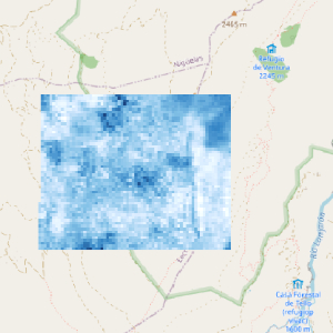
Post-fire legacies management and snow cover
by Carlos Javier NavarroThis dataset includes maps with Normalized Difference Snow Index (NDSI) values calculated from Landsat 5 SR available in the Google Earth Engine catalog (https://developers.google.com/earth-engine/datasets/catalog/landsat-5). These maps with NDSI values where used to quantify the occurrence of snow in two periods. A period before the forest fire that occurred in Lanjarón (southeast of Sierra Nevada, Spain) ranging from 2000 to 2005 and a post-fi ...(continue reading)
DOI 10.25829/ns9mh6Citation
Navarro, C. (2024). Post-fire legacies management and snow cover (Version 1) [Dataset]. German Centre for Integrative Biodiversity Research. https://doi.org/10.25829/ns9mh6Normalized Difference Snow Index
| Entities |
|---|
| Pastures |
The EBV Data Portal is supported by


