You are viewing the Initial Version, the most recent version of this dataset.
1 version(s) available
Date of publication: June 28, 2023
Version 1
Date of publication: June 28, 2023
Type of change:
Description:
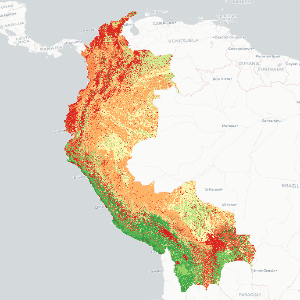
Tropical Andes species richness by macrogroup
by Jose ValdezThis dataset focuses on the Tropical Andes region, specifically Colombia, Peru, Ecuador, and Bolivia, aiming to analyze species richness by macrogroup habitat type. The methodology involved utilizing recent (~2010) distribution maps of terrestrial ecosystem types as indicators for the study area. Natural terrestrial ecosystem types were defined at the macrogroup level according to the International Vegetation Classification (IVC). Species richnes ...(continue reading)
DOI 10.25829/8md3v9Citation
Valdez, J. (2023). Tropical Andes species richness by macrogroup (Version 1) [Dataset]. German Centre for Integrative Biodiversity Research. https://doi.org/10.25829/8md3v9Key Biodiversity AreasTAOIVCIUCN Species Richness
| Entities |
|---|
| Open Water |
| Urban |
| Agriculture |
| Pasture |
| Eastern Pacific Mangrove |
| Western Atlantic & Caribbean Mangrove |
| Neotropical Floating & Submerged Freshwater Marsh |
| Western Amazon Savanna |
| Central Amazon Savanna |
| Northern Andean Montane & Upper Montane Grassland & Shrubland |
| Bolivian-Tucuman Montane Grassland & Shrubland |
| Moist Puna Grassland & Scrub |
| Pacific Mesoamerican Seasonal Dry Forest |
| Guajiran Seasonal Dry Forest |
| Llanos Seasonal Dry Forest |
| Tumbes Guayaquil Seasonal Dry Forest |
| Cerrado Seasonal Dry Forest |
| Northern Andean Seasonal Dry Forest |
| Central Andean Seasonal Dry Forest |
| Bolivian-Tucuman Seasonal Dry Forest |
| Catatumbo Magdalena Humid Forest |
| Choco-Darien Humid Forest |
| Western Ecuadorian Humid Forest |
| Llanos Humid Forest |
| Western Guianan Humid Forest |
| Orinoquian Humid Forest |
| Western Amazon Lowland Humid Forest |
| Western Amazon Subandean Humid Forest |
| Southwestern Amazon Lowland Humid Forest |
| Southwestern Amazon Subandean Humid Forest |
| Northern Amazon Humid Forest |
| Central Amazon Humid Forest |
| Cerrado Humid Forest |
| Northern Andean Montane & Upper Montane Humid Forest |
| Northern Andean Lower Montane Humid Forest |
| Central Andean (Yungas) Montane & Upper Montane Humid Forest |
| Central Andean (Yungas) Lower Montane Humid Forest |
| Bolivian-Tucuman Montane & Upper Montane Humid Forest |
| Bolivian-Tucuman Lower Montane Humid Forest |
| Moist Puna Humid Forest |
| Eastern Subandean Ridge Montane Humid Forest |
| Mesoamerican Floodplain Forest |
| Guajiran Flooded Forest |
| Choco-Darien Floodplain Forest |
| Llanos Flooded & Swamp Forest |
| Guayaquil Flooded & Swamp Forest |
| Guianan Riparian Forest |
| Northern Andean Riparian Forest |
| Central Andean Riparian Forest |
| Bolivian-Tucuman Dry Valley Riparian Forest |
| Eastern Subandean Ridge Flooded Forest |
| Western Amazon Floodplain Forest |
| Western Amazon Swamp Forest |
| Southwestern Amazon Floodplain Forest |
| Southern Amazon Swamp Forest |
| Northern Amazon Floodplain Forest |
| Central Amazon Floodplain Forest |
| South-Central Amazon Floodplain Forest |
| Cerrado Floodplain Forest |
| Beni Chiquitano Swamp Forest |
| Beni Floodplain Forest |
| Pantanal Floodplain Forest |
| Northern Chaco Floodplain Forest & Woodland |
| Northern Chaco Riparian Scrub & Woodland |
| Llanos Upland Savanna |
| Western Guianan Savanna& Shrubland |
| Cerrado Savanna |
| Northern Andean Paramo |
| Central Andean (Yungas) Upper Montane Grassland & Shrubland |
| Orinoquian Floodplain Peat Meadow & Marsh |
| Tropical Andes Upper Montane Bog |
| Mesoamerican Freshwater Marsh, Wet Meadow & Shrubland |
| Llanos Flooded Savanna |
| Central Guianan Flooded Savanna |
| Northern Andean Wet Meadow |
| Andean Puna Wet Meadow |
| Amazonian-Guianan White Sand Flooded Savanna & Shrubland |
| Upper Amazon Wet Meadow & Shrubland |
| Cerrado Flooded Savanna |
| Beni Flooded Savanna |
| Pantanal Floodplain Wet Meadow & Shrubland |
| Central Andean Altiplano Salt Flats |
| Guajiran Xeromorphic Scrub & Woodland |
| Tumbesian Xeromorphic Scrub & Woodland |
| Northern Andean Xeromorphic Scrub & Woodland |
| Central Andean Xeromorphic Scrub & Woodland |
| Bolivian-Tucuman Xeromorphic Scrub & Woodland |
| Northwestern Chaco Xeromorphic Scrub & Woodland |
| Northern Interandean Xeromorphic Scrub & Grassland |
| Central Interandean Xeromorphic Scrub & Grassland |
| Northern Chaco Xeromorphic Scrub & Savanna |
| Sechura Atacama Semi-Desert Riparian Scrub |
| Sechura Atacama Semi-Desert Scrub |
| Xeric Puna Succulent Scrub |
| Monte Cool Semi-Desert Scrub & Grassland |
| High Northern Andean Super-Paramo |
| High Andean Moist Puna Bunch Grassland |
| High Andean Xeric Puna Bunch Grassland |
| Northern Andean Cliff, Scree & Rock Vegetation |
| Sechura Atacama Semi-Desert Cliff & Pavement |
| Tropical Andean Pondshore & Wet Meadow |
| Brazilian-Parana Cliff, Scree & Rock Vegetation |
| Cerradao Sclerophyllous Woodland |
The EBV Data Portal is supported by


