With the confirm button you will delete the dataset.
Please note that you will delete all corresponding information about the dataset.
Do you really want to continue?
Change Status
In DRAFT mode the user who submitted the dataset has editing rights for the dataset.
Submit for review
With the confirm button you agree to submit the dataset for review.
Additional information
Add a few keywords that describe the dataset. Press enter after each keyword.
Upload a preview image (JPG or PNG) which represents the dataset in the best possible way.
Upload Preview Image
Select the appropriate section for the preview image
Delete User
With the confirm button you will delete the user.
You are viewing Version 2, the most recent version of this dataset.
2 version(s) available
Date of publication: August 1, 2023
Version 2
Date of publication: August 1, 2023
Type of change: Metadata
Description: changed: title, entity-value, moved some of the summary into the comment
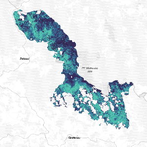
Canopy Chlorophyll Content for the Bavarian Forest National Park
by Elnaz Neinavaz
The canopy chlorophyll content for the Bavarian Forest National Park (BFNP) in Germany at 10 meters resolution on monthly basis for the year 2020. Dataset generated under Showcase. 4, pilot 4.3 myVARIABLE of the e-shape project. Canopy Chlorophyll Content (CCC) is the total amount of chlorophyll a and b pigments in a contiguous group of plants per unit ground area often expressed in mg/m2 (Gitelson et al., 2005). It is a product of leaf chlorophy ...(continue reading)
Neinavaz, E., Nieuwenhuis, W. (2023). Canopy Chlorophyll Content for the Bavarian Forest National Park (Version 2) [Dataset]. German Centre for Integrative Biodiversity Research. https://doi.org/10.25829/63zr4m
Canopy Chlorophyll Contente-shapeRemote Sensing-EBVsBavarian Forest National Park