You are viewing the Initial Version, the most recent version of this dataset.
1 version(s) available
Date of publication: June 10, 2022
Version 1
Date of publication: June 10, 2022
Type of change:
Description:
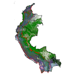
Tropical Andes formation ecosystem extent
by Jose ValdezThis dataset focuses on the Tropical Andes region of Colombia, Peru, Ecuador, and Bolivia. We demonstrate indicators in the Tropical Andes using both potential (pre-industrial) and recent (~2010) distribution maps of terrestrial ecosystem types. We measure long-term ecosystem loss, representation of ecosystem types within current protected areas, and quantify the additional representation offered by protecting Key Biodiversity Areas. The mapped p ...(continue reading)
DOI 10.25829/c8rz53Citation
Valdez, J., Comer, P., Fernandez, M. (2022). Tropical Andes formation ecosystem extent (Version 1) [Dataset]. German Centre for Integrative Biodiversity Research (iDiv) Halle-Jena-Leipzig. https://doi.org/10.25829/c8rz53WDPAProtected AreasKBAKey Biodiversity AreasHistorical loss
| Entities |
|---|
| Mangrove |
| Warm Desert & Semi-Desert Scrub & Grassland |
| Tropical Freshwater Aquatic Vegetation |
| Tropical Lowland Grassland, Savanna & Shrubland |
| Tropical Montane Grassland & Shrubland |
| Tropical Seasonally Dry Forest |
| Tropical Lowland Humid Forest |
| Tropical Montane Humid Forest |
| Tropical Flooded & Swamp Forest |
| Tropical Freshwater Marsh, Wet Meadow & Shrubland |
| Tropical Bog & Fen |
| Salt Marsh |
| Mediterranean Scrub & Grassland |
| Tropical Thorn Woodland |
| Cool Semi-Desert Scrub & Grassland |
| Tropical High Montane Scrub & Grassland |
| Tropical Cliff, Scree & Other Rock Vegetation |
| Warm Desert & Semi-Desert Cliff, Scree & Other Rock Vegetation |
| Cool Semi-Desert Cliff, Scree & Other Rock Vegetation |
The EBV Data Portal is supported by


