You are viewing the Initial Version, the most recent version of this dataset.
1 version(s) available
Date of publication: June 10, 2022
Version 1
Date of publication: June 10, 2022
Type of change:
Description:
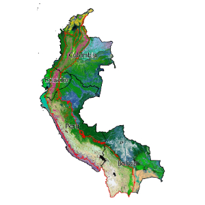
Tropical Andes macrogroup ecosystem extent
by Jose ValdezThis dataset focuses on the Tropical Andes region of Colombia, Peru, Ecuador, and Bolivia. We demonstrate indicators in the Tropical Andes using both potential (pre-industrial) and recent (~2010) distribution maps of terrestrial ecosystem types. We measure long-term ecosystem loss, representation of ecosystem types within current protected areas, and quantify the additional representation offered by protecting Key Biodiversity Areas. The mapped p ...(continue reading)
DOI 10.25829/xe5m37Citation
Valdez, J., Comer, P., Fernandez, M. (2022). Tropical Andes macrogroup ecosystem extent (Version 1) [Dataset]. German Centre for Integrative Biodiversity Research (iDiv) Halle-Jena-Leipzig. https://doi.org/10.25829/xe5m37KBAKey Biodiversity AreasWDPAProtected AreasHistorical loss
| Entities |
|---|
| Eastern Pacific Mangrove |
| Western Atlantic & Caribbean Mangrove |
| Chaco Xeromorphic Cliff & Other Rock Vegetation |
| Neotropical Floating & Submerged Freshwater Marsh |
| Western Amazon Savanna |
| Central Amazon Savanna |
| Northern Andean Montane & Upper Montane Grassland & Shrubland |
| Bolivian-Tucuman Montane Grassland & Shrubland |
| Moist Puna Grassland & Scrub |
| Pacific Mesoamerican Seasonal Dry Forest |
| Guajiran Seasonal Dry Forest |
| Llanos Seasonal Dry Forest |
| Tumbes Guayaquil Seasonal Dry Forest |
| Cerrado Seasonal Dry Forest |
| Parana Seasonal Dry Forest |
| Northern Andean Seasonal Dry Forest |
| Central Andean Seasonal Dry Forest |
| Bolivian-Tucuman Seasonal Dry Forest |
| Mesoamerican Lowland Humid Forest |
| Guajiran Humid Forest |
| Catatumbo Magdalena Humid Forest |
| Choco-Darien Humid Forest |
| Western Ecuadorian Humid Forest |
| Llanos Humid Forest |
| Western Guianan Humid Forest |
| Central Guianan Humid Forest |
| Orinoquian Humid Forest |
| Western Amazon Lowland Humid Forest |
| Western Amazon Subandean Humid Forest |
| Southwestern Amazon Lowland Humid Forest |
| Southwestern Amazon Subandean Humid Forest |
| Northern Amazon Humid Forest |
| Central Amazon Humid Forest |
| Cerrado Humid Forest |
| Central Guianan Montane Humid Forest |
| Northern Andean Montane & Upper Montane Humid Forest |
| Northern Andean Lower Montane Humid Forest |
| Central Andean (Yungas) Montane & Upper Montane Humid Forest |
| Central Andean (Yungas) Lower Montane Humid Forest |
| Bolivian-Tucuman Montane & Upper Montane Humid Forest |
| Bolivian-Tucuman Lower Montane Humid Forest |
| Moist Puna Humid Forest |
| Eastern Subandean Ridge Montane Humid Forest |
| Mesoamerican Coastal Plain Swamp Forest |
| Mesoamerican Floodplain Forest |
| Guajiran Flooded Forest |
| Choco-Darien Floodplain Forest |
| Llanos Flooded & Swamp Forest |
| Guayaquil Flooded & Swamp Forest |
| Guianan Riparian Forest |
| Guianan Swamp Forest |
| Northern Andean Riparian Forest |
| Central Andean Riparian Forest |
| Bolivian-Tucuman Dry Valley Riparian Forest |
| Eastern Subandean Ridge Flooded Forest |
| Western Amazon Floodplain Forest |
| Western Amazon Swamp Forest |
| Southwestern Amazon Floodplain Forest |
| Southern Amazon Swamp Forest |
| Northern Amazon Floodplain Forest |
| Central Amazon Floodplain Forest |
| South-Central Amazon Floodplain Forest |
| Cerrado Floodplain Forest |
| Beni Chiquitano Swamp Forest |
| Beni Floodplain Forest |
| Pantanal Floodplain Forest |
| Northern Chaco Floodplain Forest & Woodland |
| Northern Chaco Riparian Scrub & Woodland |
| Northern Chaco Palm Swamp |
| Llanos Upland Savanna |
| Central Guianan Savanna & Shrubland |
| Western Guianan Savanna& Shrubland |
| Cerrado Savanna |
| Northern Andean Paramo |
| Central Andean (Yungas) Upper Montane Grassland & Shrubland |
| Brazilian-Parana Montane Grassland, Savanna & Forb Meadow |
| Orinoquian Floodplain Peat Meadow & Marsh |
| Tropical Andes Upper Montane Bog |
| Mesoamerican Freshwater Marsh, Wet Meadow & Shrubland |
| Llanos Flooded Savanna |
| Central Guianan Flooded Savanna |
| Western Guianan Flooded Savanna & Shrubland |
| Northern Andean Wet Meadow |
| Andean Puna Wet Meadow |
| Amazonian-Guianan White Sand Flooded Savanna & Shrubland |
| Upper Amazon Wet Meadow & Shrubland |
| Cerrado Flooded Savanna |
| Beni Flooded Savanna |
| Pantanal Floodplain Wet Meadow & Shrubland |
| Parana Floodplain Wet Meadow & Shrubland |
| Chaco Riparian Marsh & Shrubland |
| Eastern Chaco Marsh & Flooded Savanna |
| Tropical Western Atlantic-Caribbean Salt Marsh |
| Mesoamerican-South American Pacific Coastal Salt Marsh |
| Chaco-Espinal Brackish Marsh |
| Central Andean Altiplano Salt Flats |
| South American Pacific Desert Salt Flats |
| Southern Andean Mediterranean Montane Scrub & Forb Meadow |
| Southern Andean Montane Salt Marsh |
| Guajiran Xeromorphic Scrub & Woodland |
| Tumbesian Xeromorphic Scrub & Woodland |
| Northern Andean Xeromorphic Scrub & Woodland |
| Central Andean Xeromorphic Scrub & Woodland |
| Bolivian-Tucuman Xeromorphic Scrub & Woodland |
| Northwestern Chaco Xeromorphic Scrub & Woodland |
| Northern Interandean Xeromorphic Scrub & Grassland |
| Central Interandean Xeromorphic Scrub & Grassland |
| Bolivian-Tucuman Interandean Xeromorphic Scrub & Grassland |
| Northern Chaco Xeromorphic Scrub & Savanna |
| Sechura Atacama Semi-Desert Riparian Scrub |
| Sechura Atacama Semi-Desert Scrub |
| Xeric Puna Succulent Scrub |
| Mediterranean Andean Cool Semi-Desert Scrub & Grassland |
| Monte Cool Semi-Desert Scrub & Grassland |
| High Northern Andean Super-Paramo |
| High Andean Moist Puna Bunch Grassland |
| High Andean Xeric Puna Bunch Grassland |
| Northern Andean Cliff, Scree & Rock Vegetation |
| Bolivian-Tucuman Cliff, Scree & Rock Vegetation |
| Moist Puna Cliff, Scree & Rock Vegetation |
| Sechura Atacama Semi-Desert Cliff & Pavement |
| Andean Cool Semi-Desert Rock Vegetation |
| Tropical Andean Pondshore & Wet Meadow |
| Brazilian-Parana Cliff, Scree & Rock Vegetation |
| Cerrado Sclerophyllous Woodland |
The EBV Data Portal is supported by


