You are viewing Version 2, the most recent version of this dataset.
2 version(s) available
Date of publication: November 21, 2022
Version 2
Date of publication: November 21, 2022
Type of change: Metadata
Description: Changed the explanation of the metric.
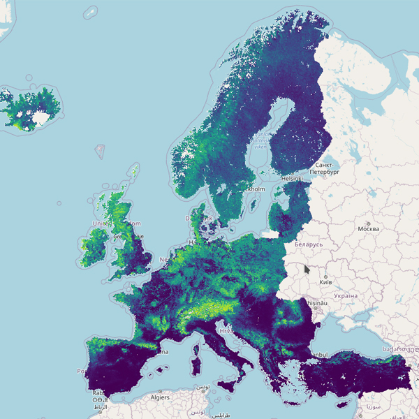
Predicted suitability for EUNIS habitat types
by Stephan HennekensThe modelled suitability for the EUNIS habitat types is an indication of where conditions are favourable for each habitat type based on classified sample plot data (European Vegetation Archive), predictors and the Maxent software package. The modelled suitability maps may be used as a proxy for the potential geographical distribution of the habitat types in given environmental and climatic envelopes. Note however that the suitability is not repre ...(continue reading)
DOI 10.25829/veyq27Citation
Hennekens, S. (2022). Predicted suitability for EUNIS habitat types (Version 2) [Dataset]. German Centre for Integrative Biodiversity Research (iDiv) Halle-Jena-Leipzig. https://doi.org/10.25829/veyq27EuropeTerrestrial ecosystemEUNISMaxentRemote Sensing-EBVs
| Entities |
|---|
| Acidophilous Quercus forest |
| Alkaline, calcareous, carbonate-rich small-sedge spring fen |
| Alnus cordata forest |
| Alnus glutinosa-Alnus incana forest on riparian and mineral soils |
| Alpine and subalpine calcareous grassland of the Balkans and Apennines |
| Alpine and subalpine ericoid heath |
| Alpine and subalpine Juniperus scrub |
| Arctic-alpine calcareous grassland |
| Arctic-alpine rich fen |
| Balkan and Anatolian oromediterranean dry grassland |
| Blanket bog |
| Boreal and arctic acidophilous alpine grassland |
| Broadleaved deciduous plantation of non site-native trees |
| Broadleaved evergreen plantation of non site-native trees |
| Broadleaved mire forest on acid peat |
| Broadleaved swamp forest on non-acid peat |
| Calcareous quaking mire |
| Carpinus and Quercus mesic deciduous forest |
| Central Mediterranean mountain hedgehog-heath |
| Coniferous plantation of non site-native trees |
| Continental dry grassland (true steppe) |
| Continental inland salt steppe |
| Corylus avellana scrub |
| Cryptogam- and annual-dominated vegetation on calcareous and ultramafic rock outcrops |
| Cryptogam- and annual-dominated vegetation on siliceous rock outcrops |
| Dark taiga |
| Dry heath |
| Dry steppic submediterranean pasture of the Amphi-Adriatic region |
| Eastern garrigue |
| Eastern Mediterranean mountain hedgehog-heath |
| Eastern Mediterranean spiny heath (phrygana) |
| Extremely rich moss-sedge fen |
| Fagus forest on acid soils |
| Fagus forest on non-acid soils |
| Forest fringe of acidic nutrient-poor soils |
| Heavy-metal dry grassland of the Balkans |
| Heavy-metal grassland in Western and Central Europe |
| Herbaceous forest clearing vegetation |
| Iberian oromediterranean basiphilous dry grassland |
| Iberian oromediterranean siliceous dry grassland |
| Iberian summer pasture (vallicar) |
| Ilex aquifolium forest |
| Inland saline or brackish helophyte bed |
| Inland sanddrift and dune with siliceous grassland |
| Intermediate fen and soft-water spring mire |
| Low and medium altitude hay meadow |
| Low steppic scrub |
| Lowland moist or wet tall-herb and fern fringe |
| Lowland to montane temperate and submediterranean genistoid scrub |
| Lowland to montane temperate and submediterranean Juniperus scrub |
| Lowland to montane, dry to mesic grassland usually dominated by Nardus stricta |
| Mainland laurophyllous forest |
| Mediterranean and Balkan subalpine Pinus heldreichii-Pinus peuce forest |
| Mediterranean and Macaronesian riparian forest |
| Mediterranean annual-rich dry grassland |
| Mediterranean closely grazed dry grassland |
| Mediterranean Cupressaceae forest |
| Mediterranean evergreen Quercus forest |
| Mediterranean gypsum scrub |
| Mediterranean halo-nitrophilous scrub |
| Mediterranean inland salt steppe |
| Mediterranean lowland to submontane Pinus forest |
| Mediterranean maquis and arborescent matorral |
| Mediterranean montane Cedrus forest |
| Mediterranean montane Pinus sylvestris-Pinus nigra forest |
| Mediterranean mountain Abies forest |
| Mediterranean riparian scrub |
| Mediterranean short moist grassland of lowlands |
| Mediterranean short moist grassland of mountains |
| Mediterranean tall humid inland grassland |
| Mediterranean tall perennial dry grassland |
| Mediterranean thermophilous deciduous forest |
| Mediterranean to Atlantic open, dry, acid and neutral grassland |
| Mesic permanent pasture of lowlands and mountains |
| Moist or wet mesotrophic to eutrophic hay meadow |
| Moist or wet mesotrophic to eutrophic pasture |
| Montane to subalpine moist or wet tall-herb and fern fringe |
| Mountain hay meadow |
| Non-calcareous quaking mire |
| Oceanic to subcontinental inland sand grassland on dry acid and neutral soils |
| Oceanic valley mire |
| Olea europaea-Ceratonia siliqua forest |
| Open Iberian supramediterranean dry acid and neutral grassland |
| Pannonian and Pontic sandy steppe |
| Perennial rocky calcareous grassland of subatlantic-submediterranean Europe |
| Perennial rocky grassland of Central and South-Eastern Europe |
| Perennial rocky grassland of the Italian Peninsula |
| Picea mire forest |
| Pinus and Larix mire forest |
| Pinus sylvestris light taiga |
| Poor fen |
| Pteridium aquilinum vegetation |
| Raised bog |
| Ravine forest |
| Relict mire of Mediterranean mountains |
| Salix fen scrub |
| Semi-dry perennial calcareous grassland (meadow steppe) |
| Shrub tundra |
| Small-helophyte bed |
| Snow-bed vegetation |
| Southern European mountain Betula and Populus tremula forest on mineral soils |
| Spartium junceum scrub |
| Subalpine and subarctic deciduous scrub |
| Subalpine genistoid scrub of the Amphi-Adriatic region |
| Subalpine Pinus mugo scrub |
| Subarctic and alpine dwarf Salix scrub |
| Submediterranean moist meadow |
| Submediterranean pseudomaquis |
| Tall-helophyte bed |
| Tall-sedge base-rich fen |
| Tall-sedge bed |
| Taxus baccata forest |
| Temperate acidophilous alpine grassland |
| Temperate and boreal moist or wet oligotrophic grassland |
| Temperate and boreal mountain Betula and Populus tremula forest on mineral soils |
| Temperate and submediterranean montane Pinus sylvestris-Pinus nigra forest |
| Temperate and submediterranean thermophilous deciduous forest |
| Temperate and submediterranean thorn scrub |
| Temperate continental Pinus sylvestris forest |
| Temperate forest clearing scrub |
| Temperate hardwood riparian forest |
| Temperate inland salt marsh |
| Temperate mountain Abies forest |
| Temperate mountain Picea forest |
| Temperate riparian scrub |
| Temperate Rubus scrub |
| Temperate Salix and Populus riparian forest |
| Temperate subalpine Larix, Pinus cembra and Pinus uncinata forest |
| Thermomediterranean arid scrub |
| Thermophilous forest fringe of base-rich soils |
| Western acidophilous garrigue |
| Western basiphilous garrigue |
| Western Mediterranean mountain hedgehog-heath |
| Western Mediterranean spiny heath |
| Wet heath |
The EBV Data Portal is supported by


